Settings, Account & Workspace
Purpose: Configure the device, account, and workspace for the intended work.
Before you start: Access to the relevant settings; workspace changes may require an administrator.
Expected result: The chosen settings are saved and checked on the working device.
Use Settings to manage your account, devices, workspace access, map behavior, offline tiles, subscriptions, and application preferences.
1. Opening the Sidebar
Tap the hamburger menu (☰) in the top-left corner to slide open the sidebar panel. The sidebar provides access to:
- Account & Profile — View and manage your account
- Settings — Configure map and app behavior
- Geova AI — Quick access to the AI assistant
- Offline Maps — Download and manage tile caches
- Map PDF Export — Generate print-quality documents
- Upgrade to Pro — Access premium features
- Help & About — Documentation and app info
2. Account Settings
Tap Account in the sidebar to open the Account Settings modal.
Profile Information
- Full Name — Your display name across the platform
- Email — Your registered email address
- Plan Type — The current workspace plan; check feature access separately from hosted-project capacity
Storage Indicator
A progress bar shows your current storage usage:
- Cloud users — Shows
XX MB of YY MB cloud allocation - Offline/local users — Shows
XX MB local project data on this device - Color-coded: Green (under 50%), Amber (50–80%), Red (80%+)
Device Management
Mapplex allows a maximum of 2 trusted devices per account.
- A device list shows all registered devices with:
- Device name
- Last active date
- ✅ Green indicator for the current device
- De-register — Remove a device to free up a slot. If you de-register the current device, you'll be signed out immediately.
- A progress bar shows
X of 2 Slotsused
AI Credit Recharge
Tap Recharge to view the available Geova AI credit options for your workspace.
3. App Settings
Tap Settings in the sidebar. Most switches apply immediately; use Save wherever it is shown. X or Done closes the menu and keeps you on your current view. Use search to find a setting, or expand General, Map display, Field tools, Phone capture, or RTK. Search also opens matching RTK administration options.
Map display and Phone capture
| Setting | Default | Description |
|---|---|---|
| GPS Accuracy Indicator | ✅ On | Shows a live accuracy dot on the GPS button, color-coded by signal quality |
| Enhanced Phone Capture | ❌ Off | Collects and validates multiple phone positions before saving a point or vertex; external RTK workflows are unchanged |
| Maximum phone position uncertainty | 10 m | Available under Phone capture when Enhanced Phone Capture is on. Choose 5, 10, or 15 m as the acceptance limit. Lower limits can require more retries; no accuracy is guaranteed. |
| Map Rotation | ❌ Off | Enables compass-based map rotation. Finish or cancel drawing, measuring, sketching, or location capture before changing rotation |
| Zoom Controls | ❌ Off | Shows +/- zoom buttons on the map. Hides them when off (pinch zoom still works) |
| Feature Clustering | ✅ On | Groups nearby features into clusters at lower zoom levels for performance |
RTK
Open RTK → RTK Demo to practice with simulated data. The demo uses simulated receiver readings. It does not connect to or validate a real receiver. Demo points remain separate from project data.
Expand RTK access and workspace administration for access status, refresh, collector assignments, and device registration. Availability depends on your role and workspace access. Expiry inputs use your device’s local time. If the collector list fails to load, use Retry collector list or Refresh access. These RTK actions use their own explicit buttons.
Field Tools
| Setting | Default | Description |
|---|---|---|
| Manual Coordinate Entry | ❌ Off | Adds decimal latitude/longitude entry for a point or a line/polygon vertex |
| GPS Recording Tools | ❌ Off | Shows GPS track recording and silent recording buttons on the map |
| Advanced Edit | ❌ Off | Shows the Owner/Admin side-panel entry for polygon split and merge |
| Sketch Mode | ❌ Off | Enables local project annotations through Sketch Tools; separate from collected features |
| Quick Capture | ❌ Off | Faster point collection at your current GPS location; complete the form and confirm the save. Eligible workspaces can also use Fill by voice inside its form; voice access is enabled separately |
| Work map icon | ✅ On | Shows or hides the Work map shortcut when Work is available; does not change orders or permissions |
| Slope Profiler | ❌ Off | Enables the digital clinometer tool (see Module 09) |
| Use radial drawing controls | ✅ On | Uses the long-press radial tools and hides the floating drawing toolbar |
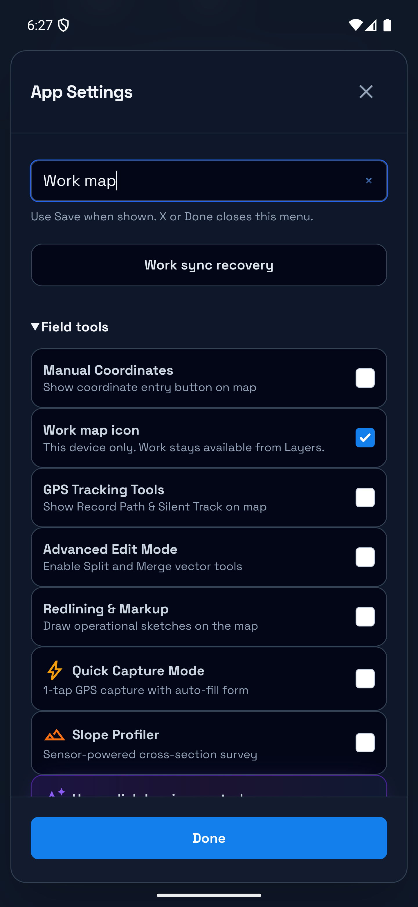
Find the Work map shortcut setting
Search Settings for Work map, then open Field tools. Turn Work map icon off to hide the shortcut on this device, or on to restore it when Work is available. You can still open Work from Layers.
Choosing drawing controls
Use radial drawing controls is on by default. Long-press the map on touch devices or right-click on desktop to open actions for empty space, a feature, or a cluster. Turn it off to restore the floating drawing toolbar and measurement button.
After entering a task, use its bottom action bar. Precision crosshair drawing keeps this bar available even with the toolbar shown. Follow Contextual drawing and precision controls.
General language and Map display formats
| Setting | Default | Description |
|---|---|---|
| Language | English | Switch between English (en), Arabic (ar), Spanish (es), and French (fr) |
| Coordinate Format | WGS84 DD | Choose between decimal degrees, DMS, or EPSG:3857 Web Mercator display |
| Measurement Unit | Metric | Switch existing map measurement labels and automatic geometry displays between metric and imperial. Stored geometry and source field units do not change |
General — screen behavior
| Setting | Default | Description |
|---|---|---|
| Keep Screen Awake | ✅ On | Prevents the device screen from sleeping during fieldwork. Its status shows whether the device granted the request, is waiting, paused in the background, or unavailable |
Tip: For longer field sessions, turn off GPS Accuracy Indicator and Map Rotation when you do not need them. Keep Screen Awake is useful during active collection but can increase battery use.
Arabic changes text direction inside translated content while the application shell, buttons, icons, navigation order, and control locations remain stable. Spanish and French use the same left-to-right layout as English. Project names, layer names, field names, and collected values remain exactly as entered and are never replaced by interface translations.
4. Workspace Switcher
If your account belongs to multiple organizations, the Workspace Switcher lets you change environments without signing out.
What is a Workspace?
A Workspace is your team’s separate area for projects, members, and access. Everything — projects, layers, forms, team members, and data — belongs to a workspace. Different workspaces are completely separated for data isolation and security.
Switching Workspaces
- Open the sidebar.
- Your current workspace name appears below your profile.
- Tap the workspace name to open the Workspace Switcher.
- A list of all workspaces you've been invited to appears.
- Tap a workspace to switch. Mapplex reloads the project list and related workspace data.
Example: A consulting firm manages separate contracts for a road audit and a utility survey. The project manager switches workspaces to review the correct project list, members, and storage usage for each contract.
5. Offline Map Manager
Tap Offline Maps in the sidebar to open the Offline Map Manager.
Downloading Tiles
Tap Download Map Area to cache the currently visible map tiles for offline use. This stores available tiles from the selected basemap on the device. Before fieldwork, disconnect and check the whole working area at the zoom levels you need; a completed progress bar alone does not confirm that every tile is available.
Clearing Cache
Tap Clear Offline Cache to delete all downloaded map tiles. A confirmation dialog appears before deletion. This frees device storage but requires re-downloading for future offline use.
When to clear: Clear the cache when offline tiles are taking too much storage or when downloaded tiles need to be refreshed.
6. Subscription & Entitlements
Feature availability is controlled by your workspace plan and enabled features. If a tool is not included in your current workspace, Mapplex shows a lock state or upgrade prompt instead of silently failing.
Free / Core Access
The default free workspace is intended for solo or lightweight field work:
- Local projects on the current device
- One hosted project in the free workspace
- Layer creation, form setup, drawing, GPS capture, and feature collection according to your role
- GPS recording tools and redlining/markup when enabled
- Export to GeoJSON, KMZ, and CSV
Hosted-project allowances and Planner access
| Plan | Hosted projects per workspace | Planner |
|---|---|---|
| Pro | 5 | Not included |
| Teams | 10 | Enabled workspaces and permitted roles only |
| Enterprise | 20 | Enabled workspaces and permitted roles only |
Local projects do not use hosted slots. Planner is not unlocked by Pro's project allowance. Creation still needs Owner/Admin authority and enabled creation access. Check the live capacity message before designing or creating; see Plans and access.
Paid features and separate requirements
When a locked feature is accessed, Mapplex can show an upgrade prompt. The following tools have their own plan, role and workspace requirements; this is not a promise that one paid plan unlocks everything:
| Feature | Description |
|---|---|
| Geova AI Chat | Natural-language queries, spatial analysis planning, and report/export assistance |
| GeoPackage, GDB, and PDF Export | GIS handoff and print-ready map output; GDB conversion needs sign-in and an internet connection |
| Team Workspace Tools | Collaboration, member roles, realtime sync, and audit history where enabled |
| Lexicon Picklists | Project-wide shared dropdown registries |
| Gallery Fields | Multi-photo form fields with carousel |
| Smart Logic | Conditional form rules |
| Spreadsheet and Reference Imports | CSV/Excel point import and spatial reference zones |
| Advanced Symbology | Graduated classification and completion indicators |
| Quick Capture and Slope Profiler | Faster field capture and phone-based slope profiling |
| CAD and SHP Managers | DXF and Shapefile import/export workflows |
Note: Team and Enterprise workspaces may have additional limits or enabled features, including longer audit-history retention and larger collaboration allowances.
7. Help & About
Help Modal
Tap Help in the sidebar to access:
- Interactive Tour — A guided walkthrough of the app's main features
- Documentation — Opens the online documentation at geova.net/docs
About Modal
Tap About to view:
- App version number
- Build information
- Links to privacy policy and terms of service
Account and Data Controls
Signed-in users can open Account Profile → Account & Data Controls → Request account deletion. Mapplex opens the public deletion resource at https://www.geova.net/account-deletion, where the user can review what is deleted or retained and initiate a verified request. Opening the page does not immediately delete anything.
The same Request account deletion link is available from the sign-in screen and the sidebar Help & Legal section, so a user can start a request without being signed in. Account deletion does not automatically cancel a Google Play subscription; subscriptions must be managed separately in Google Play.
Changing the application language
Open Settings → General → Language and choose English, Arabic, Spanish, or French. Use the language picker and check the selected item/checkmark before closing it. The choice is retained for the next launch. The sign-in screen also has a language picker. English and Arabic are the main languages covered by this guide; Arabic content uses right-to-left writing direction; application navigation and map controls keep their established locations. Names and values entered by your team are not automatically translated. On phones, scroll within a long panel to reach every field; on tablets, close the expanded navigation drawer when it covers the task. If a button is disabled, read the nearby reason—capacity, unanswered questions, missing choices, role or an operation in progress—rather than repeatedly tapping it.
Next: Proceed to Module 09: Slope Profiler to record a phone-based slope profile.